|
|
|
Detour to Everest, continued
 | Click to Enlarge. |
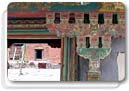
Just before dark we made it to Xegar. Our hotel was much more palatable. Lakba secured all the permits while the five of us went to have dinner. We found a great little Tibetan hangout, the Kong Jong. Cozy couches lined the walls, brightly painted wooden eaves crisscrossed the ceiling, and in the middle was a Tibetan wood-fired stove. The proprietress served us Thukpa, Tibetan noodle soup, and roasted potatoes. Chinese and Tibetans watched Chinese marshal dramas on television as they smoked cigarettes and sipped their yak butter tea.
 | Click to Enlarge. |
Outside the restaurant, little kids swarmed around us. They were peddling oceanic fossils that they had dug up in the local hills. Before the Indian subcontinent crashed into Asia and created the Himalayas, these sea creature skeletons were imbedded in rock. They were remnants from prehistoric time when Tibet bordered the ocean. In the sky above, the stars were almost blinding. Millions of lights shone brightly. They looked so close, it seemed you could touch them.
 | Click to Enlarge. |
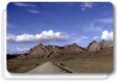
Permits in hand, for the numerous Chinese checkpoints, and after yet another breakfast of eggs and yak butter, we headed on our way to base camp. The unpaved road was even bumpier than the not so friendly Friendship Highway. The beauty, however, made up for the discomfort.
 | Click to Enlarge. |
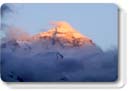
We began our ascent towards the next mountain pass. Green with hearty wild grasses and dotted with wildflowers, on these mountains we spotted our first Yaks. They were huge soft-looking hairy black beasts. Topped with fierce horns, their faces were sweet and rugged. The source of yak butter, a staple of Tibetan food that makes me want to yak, appeared calm and kind. At Pang-La pass (5120 meters / 22,000 feet) we caught our first sight of Everest.
 | Click to Enlarge. |
Silvery white peaks hung above clouds in the distance. Everest towered above. We were breathless, and not just from the lack of oxygen. Lichens, dew, frost, and prayer flags covered the ground. All five of us stood next to the sign for Qomolangma, Everest in Tibetan. We were on our way to Base Camp.
 | Click to Enlarge. |
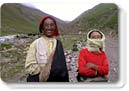
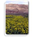
For four more hours we descended through a valley. Whizzing along a stream bed in our Land Cruiser, we paused to greet a local Tibetan man on horseback. Red yarn was braided into his hair. Rings: bone, silver and turquoise were also woven in. White nomadic tents, decorated with the Tibetan endless knot, had set up camp along the stream. Farmers tended fluorescent yellow rapeseed, and bright-green barley fields. The mountains surrounding the valley were stratified with multiple shades of brown. Severe dry ridges reached to the sky.
 | Click to Enlarge. |
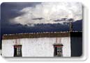
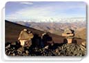
Finally we made it to Rongpu monastery, where people stay before heading of into Base Camp. White worn buildings rested a harsh landscape, behind them Everest glistened in the bright blue sky. Before the Cultural Revolution, 500 monks resided at Rongpu. Now there are only 20 nuns and one monk caretaker.
 | Click to Enlarge. |
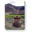
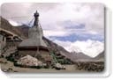
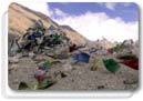
After checking into the very basic monastic lodgings, we headed out to Base Camp. In the mere thirty minutes it took to drive there, clouds covered the massif. Looking around, we imagined Sir Edmund Hilary camping at this very site. Without being acclimatized it was all we could do to climb a small mound. At the top we created our second chorten and looked out at the stark landscape. Grey and brown rocks and bluish streams made up the glacial outwash valley at Base Camp. Michael and Imed, decided to try and climb. After an hour they returned giddy and exhausted like schoolboys both with their pockets full of Everest rocks.
 | Click to Enlarge. |
Late that evening Everest made a final appearance. The snow-covered giant turned yellow, then pink, and then gray as the sun set behind us. We were experiencing sunset on the highest point on earth.
 | Click to Enlarge. |
Everest did not greet us as we headed out the next morning. Only the desert like surroundings and snow-capped hills were visible. Altitude sickness had hit Will hard with a headache, dizziness and nausea. I was glad we were on our way back down.
 | Click to Enlarge. |
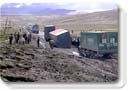
Mao headed at top speed back to the Friendship Highway. As we headed towards Lhasa, the roads got progressively worse. The Friendship Highway, the main thoroughfare connecting Tibet (China) and Nepal, is barely a dirt road. It would not even make a dotted line on a US map. We consistently encountered roadblocks with dozens of cars. Inevitably one or two trucks were at the head of the lineup continually revving their wheels in an attempt to move forward, or they were tipped over from trying. Men paced back and forth, chain smoking, from one broken down truck to the next. Ditches, mud and massive holes lay in the path of what should have been the road to Lhasa.
|